The Black Canyon Trail: One Year Later
By Sarah Sakha, contributing writer ~ Black Canyon Bullet
If you visited https://blackcanyon.mysidewalk.com/info just a year ago, you would have arrived at a rudimentary website where you could submit comments to a Discussion Board. Visit the site today and you’ll arrive at a more developed site which offers more information on the Black Canyon Recreation and Travel Management Plan and an avenue to have your voice heard in the development of the trail. The Bureau of Land Management (BLM) Hassayampa office encourages patrons to offer input on how they personally use the trail for recreational purposes so as to better suit the public’s needs.
Over the past year, considerable progress has been made in addressing these growing needs. A more diverse range of recreational opportunities is available to the public, and Special Recreation Permits (SRPs) are now permitted. These permits are required for the commercial use of this public land, as attested to by the 100K marathon and the Xterra trail run. Bumblebee Ranch also leads a commercial
operation, guiding people on horses on the trail. Granted, the trail remains nonmotorized and motorized vehicles remain prohibited.
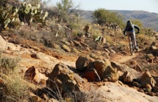
“Hiking, mountain biking, equestrians – it’s a back country experience without motorized vehicles, which it will eventually accommodate,” says Bob Cothern of the Black Canyon Community Association. Cothern is a part of the trail work group. Even though it remains non-motorized, it’s set to be an expansive project. “We are envisioning a network of trails where you can get from one point to another without ever riding on a major road,” says Skordinski. In other words, people can navigate the trails without ever encountering the same piece of trail twice.
And it’s set to expand even further. The Black Canyon Trail Coalition is waiting to obtain land and work with the Arizona Land Department to install the southernmost trailhead by the Carefree Highway. The northernmost trailhead is already in place by Highway 69 en route to Prescott, built up to the border of the Prescott National Forest. The trail system is expected to be extended into Prescott and even all the way up to the Utah border.
But admittedly, progress has been stalled for the time being. This lapse is attributable to Victor Vizcaino’s departure from the BLM Hassayampa office. Vizcaino worked with the 2010 Resource Management Plan for the development of the trail and helped develop the environmental impact statement, which took nine years to write.
Environmental assessment still continues. Sustainability and environmentalism have been goals from the start, and according to Skordinski, it still remains an important part of the trail’s development.
In addition, several other projects have come up. It’s important to note how much work is left and more importantly, how much time it will take. “This project remains in its infancy,” comments Skordinski. “Government agencies and organizations are getting together and mapping trails, land status, and how we could make this possible.”
After all, such a large-scale project needs input from a wide array of people. From its inception, it has been a joint effort, drawing support and collaboration from hikers, equestrians, mountain bikers, and hikers. And now not only are government groups joining in the effort, but so are trail advocates, or private agencies. These include the Trail Connectivity Group, a local group, the BLM, Maricopa County Parks & Recreation, Desert Botanical Gardens, Desert Foothills Land Trust, the City of Peoria, Scottsdale, Anthem, New River, Phoenix, and Cave Creek, which are all looking into the future expansion of non-motorized trails into these cities and land trusts.
Another initiative is the Sun Valley Corridor trail system, which would begin at the Mexican border, with connections to Prescott, Sedona, Verde Valley, Flagstaff, and Coconino County, all the way up to Las Vegas.
The Maricopa Trail, which currently connects into the Black Canyon Trail, will also be expanded. This is a circular trail around the metropolitan area that will connect all county parks. It is expected to span 240 miles and is 70 percent complete thus far, according to RJ Kasdin, Director of Maricopa County Parks & Recreation. It is set to be completed within the next three to four years.
Ultimately, the goal is widespread connectivity in the trail system. “We have this really great trail, spans 80 miles,” says Mary Skordinski, the recreation planner who manages the Black Canyon Trail. It’s expected to reach up to 350 miles of recreation trail.
While there may be a great ways to go, the Black Canyon Trail has certainly come a long way over the past century. Back in 1919, the trail was formerly known as the Black Canyon Stock Driveway, and it was only in 1969 that it became the Black Canyon Trail. Despite this shift, livestock are no stranger to the trails.
“Cows do occasionally walk onto the trail, but no the sheep. We have one or two cows,” says Bob Cothern. The trail remains a sheep driveway, and every April, sheep will be run on the Badger Springs Trail. But when asked whether folks minded the occasional furry guests, he chuckles and shrugs it off. “They help prevent erosion,” points out Cothern. After all, it is impossible to restrict the movement and grazing of livestock in Black Canyon City due to open range laws. According to Cothern, open range doesn’t serve as much of a hindrance; it’s just something to work around and keep in mind.
The Black Canyon Trail, still welcomes input from patrons as it continues development. If you would like to submit comments, there are visitor registration boxes located at the trailheads, where you can leave a a note or visit; http://www.blm.gov/az/st/en/prog/recreation/hiking/blk-canyon.html and http://www.bctaz.com/ to stay posted.
Editors Note; when in Black Canyon City, we welcome you at the Black Canyon Bullet office – located in Black Canyon City at Harmil Plaza.
